


The GIS & Geospatial Skills Framework
Unlock Your Expertise: Trust GIS247 with Your GIS Knowledge

At GIS247, we’ve developed a comprehensive Skills Framework designed to empower both individuals and the organisations they serve. This framework enables measurement and management of competency levels in geospatial and Geographic Information Systems (GIS). Here’s how it benefits different stakeholders:
- Organisations
- Current Competency Assessment: The framework allows organisations to assess the competency levels of entire teams across departments. By understanding employees’ expertise, organisations ensure effective job performance.
- Adding Business Value: Competency in geospatial and GIS directly impacts business outcomes. Organisations can leverage this knowledge to enhance decision-making, optimize processes, and drive growth.
- Managers
- Informed Talent Decisions: Managers gain insights into recruitment, retention, and succession strategies. Identifying skill gaps becomes easier, enabling targeted learning and development opportunities.
- Strategic Impact: Managers recognize that geospatial and GIS skills contribute to organisational success. They can align talent development with business goals.
- Individuals
- Clear Pathway to Growth: The framework provides a structured route for skill development in geospatial and GIS. Individuals can track their progress and have their achievements acknowledged.
- Professional Advancement: Whether pursuing certifications or advancing careers, the framework supports personal growth.
Navigating the GIS & Geospatial Skills Framework: Unlocking Expertise
The GIS & Geospatial Skills Framework comprises four distinct levels, each reflecting an individual’s knowledge and achievements. As you ascend the levels, your competence and expertise grow:
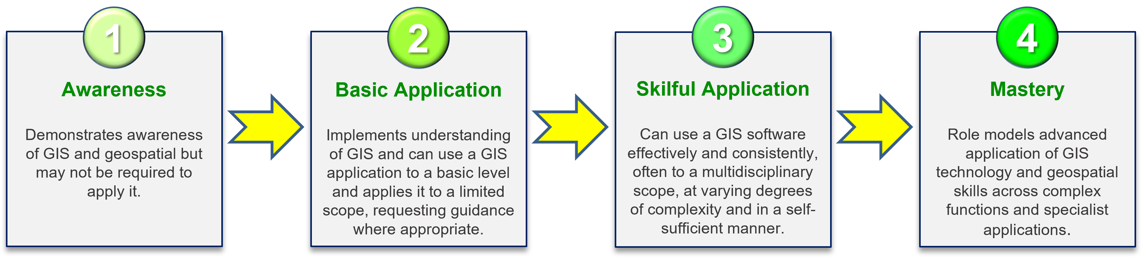
- Level 1: Awareness
- At this foundational level, individuals demonstrate awareness of GIS and geospatial concepts. While not necessarily required for direct application, understanding geospatial principles is invaluable for managers and anyone active in this sector.
- Level 2: Basic Application
- Building upon Level 1, achieving this milestone signifies the ability to implement GIS knowledge practically. Individuals can use GIS applications at a basic level, applying technology within a limited scope and seeking guidance when needed.
- Level 3: Skilful Application
- Having mastered Levels 1 and 2, Level 3 showcases effective and consistent use of GIS software. Skilled practitioners operate across multidisciplinary contexts, handling varying complexities independently.
- Level 4: Mastery
- With Levels 1, 2, and 3 under their belt, individuals at Level 4 become role models within their organisations. They tackle advanced GIS technology and geospatial challenges across complex functions and specialized applications. These experts enhance technical capabilities, leveraging geospatial approaches for the benefit of the entire organisation.
Framework Categories and Skills:
- The framework meticulously defines key skills across 13 distinct categories.
- Within each category, various skills contribute to overall proficiency.
- The diagram summarizes the number of skills required for each level across these categories.
- Remember, progression is cumulative: you must achieve the levels below to reach the next.
Tracking Progress and Recognition:
- Your journey through the Skills Framework is automatically recorded on your MyGIS247 dashboard.
- Administrators receive notifications when you achieve a level, and you’ll receive a certificate of accomplishment.
In summary, the GIS & Geospatial Skills Framework empowers individuals and organisations alike, fostering excellence in geospatial understanding and application. The Skills Framework is made available to all users from organisations with an Ultimate Licence to GIS247.
Why Choose GIS247?
Unparalleled Expertise: Our trainers are seasoned professionals, personally accredited by various bodies.
They bring real-world insights and practical know-how to your learning journey.Comprehensive Content: Dive into our meticulously crafted courses, designed to empower you with the skills needed to excel in ArcGIS.
Proven Results: Our track record speaks for itself—countless learners have trusted us to elevate their GIS proficiency.
Our great value licences can be reviewed on our Licence Pricing page.
Organisations can meet all of their GIS training needs with licences for 1 user up to unlimited user accounts.
Individuals can access ALL courses with a 1-user Set User licence, OR access single GIS training courses at our sister site GIS247Solo.
Join the GIS247 community and unlock your potential. Let’s shape your success together!